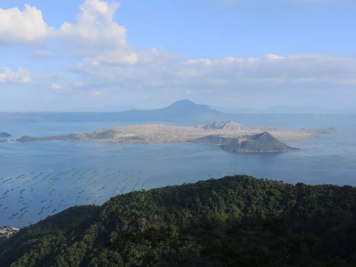
Taal Volcano, situated within a large caldera occupied by Taal Lake in the Philippines' Batangas province, stands as the country's second most active volcano. Positioned approximately 50 kilometers south of Manila, it has a recorded history of 38 eruptions, all confined to Volcano Island at the heart of Taal Lake. The caldera's formation is attributed to prehistoric eruptions occurring between 140,000 and 5,380 years ago.
1904: Formation of a New Outlet in the Main Crater
In 1904, an eruption created a new outlet in the southeastern wall of Taal Volcano's principal crater, marking a significant change in its structure.
January 1911: Devastating Eruption and Increased Seismic Activity
In January 1911, Taal Volcano experienced one of its most destructive eruptions. Starting in the late hours of January 27th, the Manila Observatory recorded escalating seismic disturbances. The increasing frequency and intensity of these earthquakes, with 26 shocks on the 27th and 217 on the 28th, caused widespread fear in Manila.
1911: Transformation of the Crater Floor and Formation of the Crater Lake
Before the 1911 eruption, Taal Volcano's crater floor was higher than Taal Lake and featured multiple openings with colorful lakes and steaming hot water holes. The eruption dramatically altered the crater, replacing these features with a single large lake. This lake, initially about ten feet below the surrounding lake level, gradually rose. A popular but later debunked theory suggested this water cooled volcanic material, reducing eruption risks.
1911: Formation of the Main Crater Lake
The eruption in 1911 led to the obliteration of the crater floor on Volcano Island, resulting in the formation of the present Main Crater Lake.
1911: Last Eruption from the Main Crater Before 2020
The last eruption from the main crater of Taal Volcano prior to 2020 occurred in 1911, resulting in the creation of the current lake by obliterating the previous crater floor.
1965: Shift of Activity to Mount Tabaro
A powerful explosion in 1965 significantly altered Taal Volcano by removing a large portion of the island and causing volcanic activity to shift to a new eruption center, Mount Tabaro.
1965: Creation of a Bay
A significant event, likely a volcanic eruption, occurred in 1965, resulting in the formation of a bay in the landscape.
1965: Recognition of "Base Surge" in Volcanic Eruptions
An American geologist, present at an atomic bomb test during his military service, observed Taal Volcano's 1965 eruption. He identified "base surge," now known as pyroclastic surge, as a volcanic process, highlighting a connection between nuclear and volcanic phenomena.
1965: Phreatomagmatic Eruption and Devastating Base Surges
Taal Volcano experienced a period of volcanic activity from 1965 to 1977, centered around Mount Tabaro. The 1965 eruption, categorized as phreatomagmatic, occurred when magma interacted with lake water, triggering a massive explosion. This event carved an embayment on Volcano Island and generated destructive "cold" base surges that traveled several kilometers across Lake Taal, resulting in significant damage to lakeside villages and the loss of around one hundred lives.
July 5, 1966: Reactivation of Taal with a Phreatomagmatic Eruption
After nine months of inactivity, Taal Volcano became active again on July 5, 1966, with a phreatomagmatic eruption from Mount Tabaro.
August 16, 1967: Another Phreatomagmatic Eruption at Mount Tabaro
Taal Volcano experienced another phreatomagmatic eruption on August 16, 1967, originating from Mount Tabaro, further indicating heightened volcanic activity during this period.
January 31, 1968: First Recorded Lava Fountaining
On January 31, 1968, Taal Volcano displayed Strombolian eruptions, which led to the first historical observation of lava fountaining at the volcano, marking a significant event in its eruptive history.
October 29, 1969: Strombolian Eruption and Lava Flows
A year after the first recorded instance of lava fountaining, Taal Volcano experienced another Strombolian eruption on October 29, 1969. The substantial lava flows from both eruptions eventually filled the bay formed by the 1965 eruption, reaching the shores of Lake Taal, significantly altering the surrounding landscape.
1976: Phreatic Eruption at Taal Volcano
Taal Volcano experienced a phreatic eruption in 1976, characterized by the expulsion of steam and volcanic material, indicating continued volcanic unrest during this period.
1977: End of a Period of Frequent Eruptions
Between 1572 and 1977, Taal Volcano experienced 54 recorded eruptions. This period saw significant volcanic activity, shaping the landscape and history of the region.
1977: Period of Relative Quiet at Taal Volcano
Following the eruption in 1977, Taal Volcano entered a period of relative inactivity. However, despite the reduced volcanic activity, the volcano still showed signs of unrest starting in 1991.
1977: Phreatic Eruption Marks the End of a Period of Activity
The final major activity in this period of heightened volcanic activity at Taal was a phreatic eruption in 1977, marking the end of a period of frequent eruptions and unrest.
1991: Signs of Unrest at Taal Despite Inactivity
Despite a period of reduced volcanic activity following the 1977 eruption, Taal Volcano began showing signs of unrest starting in 1991. These included increased seismic activity, ground fracturing, and the emergence of small mud pots and geysers on the island. This unrest prompted the Philippine Institute of Volcanology and Seismology (PHIVOLCS) to issue regular notices and warnings about the volcano's activity.
October 1994: Radon Gas Spike Precedes Mindoro Earthquake
In October 1994, a significant increase in radon gas concentration was detected in the soil of Volcano Island, followed by the magnitude 7.1 Mindoro earthquake on November 15th, 1994. This event suggested a possible correlation between radon emissions and seismic activity.
August 8, 2018: Taal Volcano Alert Signals Published
On August 8, 2018, the Philippine Institute of Volcanology and Seismology (PHIVOLCS) released information on "Taal Volcano Alert Signals."
December 17, 2019: Original Source Archived
The original source for the information on Taal Volcano Alert Signals was archived on December 17, 2019.
January 15, 2020: Information Retrieved
The archived information on Taal Volcano Alert Signals was retrieved on January 15, 2020.
January 26, 2020: Decreasing Volcanic Activity Prompts Downgrade of Alert Level
By January 26, 2020, PHIVOLCS observed a decline in volcanic activity at Taal, leading to the downgrade of the alert level from Level 4 to Level 3. While the eruption had impacted a large region, including Calabarzon, Metro Manila, and parts of Central Luzon and Ilocos Region, causing disruptions in daily life and prompting evacuations, the decreasing activity offered a sign of potential stabilization.
March 2020: Reappearance of the Main Crater Lake
After temporarily disappearing due to the 2020 eruption, the Main Crater Lake on Volcano Island reappeared in March 2020.
March 9, 2021: Increased Activity Prompts Evacuation and Alert Level Raise
In February, as Taal Volcano showed signs of heightened activity, residents of Taal Volcano Island were evacuated as a precautionary measure. On March 9, 2021, PHIVOLCS raised the alert level from 1 to 2, reflecting the increased volcanic unrest.
May 6, 2024: Taal Volcano Island Declared a "No Man's Land"
On May 6, 2024, due to a series of wildfire devastations near the Binintiang Munti observation station, Hermilando Mandanas declared Taal Volcano Island (TVI), which was under Alert Level 1-Low-level unrest, a "no man's land."
Mentioned in this timeline

An earthquake is the shaking of the Earth's surface caused...

Wildfires are unplanned uncontrolled fires in combustible vegetation also known...
Trending

2 minutes ago Frances Tiafoe Competes at Delray Beach Open Against Rinky Hijikata in 2026

3 minutes ago Danny Ramirez's 'Baton' movie expands cast with Edgar Ramirez, Eugenio Derbez, and Rosario Dawson.

1 hour ago Hillary Clinton criticizes Trump's policies at Munich Security Conference, clashing with Czech leader.

1 hour ago Giron vs. Shimabukuro: Delray Beach Open Preview, Prediction, and Odds for Round of 32

1 hour ago Marie-Philip Poulin leads Canada to the Olympic final, overcoming injury concerns.

1 hour ago Angie Harmon goes Instagram official with Tony Floyd, rekindling romance after 27 years.
Popular
Randall Adam Fine is an American politician a Republican who...

Kid Rock born Robert James Ritchie is an American musician...

Pam Bondi is an American attorney lobbyist and politician currently...

Barack Obama the th U S President - was the...
The Winter Olympic Games a major international multi-sport event held...

XXXTentacion born Jahseh Dwayne Ricardo Onfroy was a controversial yet...
