


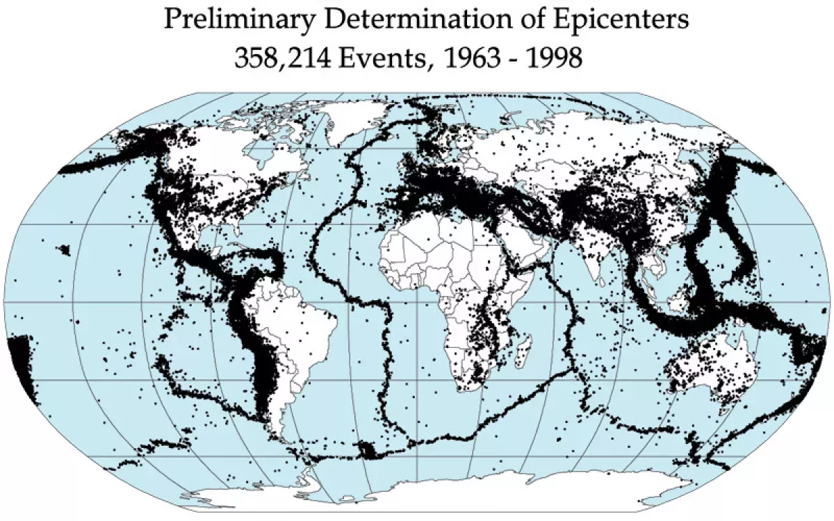
An earthquake is a sudden, intense shaking of the Earth's surface caused by the rapid release of energy in the lithosphere, which creates seismic waves. This phenomenon typically occurs when tectonic plates—massive slabs of rock forming the Earth's outer shell—shift along geological faults. As these plates move, they often become stuck due to friction; when the accumulated stress eventually overcomes this friction, the plates slip, releasing energy that radiates outward. The magnitude of an earthquake is measured using scales like the Richter or Moment Magnitude scale, while the intensity is often gauged by the Mercalli scale. While many earthquakes are minor and go unnoticed, major events can cause severe destruction, including the collapse of infrastructure, tsunamis, and landslides. Although modern technology allows scientists to monitor seismic activity and track plate movements, predicting the exact timing and location of earthquakes remains a significant scientific challenge. Preparedness, building codes, and early warning systems are the primary methods for mitigating the devastating impact of these powerful natural events.
6 hours ago : Series of Strong Earthquakes Strike Mindanao and Davao Occidental Regions
Multiple earthquakes, ranging from magnitude 5.2 to 6.4, have struck the Mindanao and Davao Occidental regions in the Philippines, raising concerns regarding seismic activity and structural safety in the affected coastal areas.


1900: Establishment of USGS Earthquake Statistical Baselines
Starting from 1900, the United States Geological Survey began collecting data, establishing an average of 18 major earthquakes (magnitude 7.0–7.9) and one great earthquake (magnitude 8.0 or greater) annually, providing a consistent metric for seismic activity analysis.
1906: The 1906 San Francisco Earthquake Fire Disaster
During the 1906 San Francisco earthquake, the city faced widespread devastation, but the majority of fatalities were ultimately attributed to the ensuing fires rather than the seismic shaking itself. The disaster was exacerbated by broken gas and electrical lines fueling the flames, combined with ruptured water mains that prevented firefighters from accessing enough pressure to control the spread of the fire throughout the year 1906.
1906: 1906 San Andreas Fault Rupture
In 1906, a notable earthquake rupture occurred along the San Andreas Fault, highlighting the behavior of strike-slip faults.
1906: The San Francisco Earthquake
The 1906 San Francisco earthquake remains a defining historical disaster that continues to shape how earthquakes are portrayed and remembered in modern popular culture.
1913: Location of the Earth's core
In 1913, Beno Gutenberg successfully determined the location of the Earth's core by analyzing seismogram data derived from earthquake wave patterns.
1931: Expansion of Seismic Monitoring Networks
In 1931, the global network of seismic stations consisted of approximately 350 units. This marked a historical baseline for earthquake detection before significant technological advancements led to the thousands of stations currently in operation.
1935: Development of the Richter Magnitude Scale
In 1935, Charles Francis Richter introduced the first standardized scale designed to measure the magnitude of earthquakes. This scale established a logarithmic foundation where each unit increase corresponds to a ten-fold increase in ground shaking amplitude and a 32-fold increase in released energy, a principle that continues to influence modern seismic measurement.
1939: 1939 North Anatolian Fault Rupture
The 1939 earthquake along the North Anatolian Fault in Turkey serves as a key historical example of rupture length on a strike-slip fault.
1946: Vancouver Island Earthquake Landslide Area
In 1946, the Vancouver Island earthquake occurred in Canada, serving as a significant event that helped elevate the nation's total landslide-affected area to 66,000 km2.
1957: 1957 Alaska Earthquake Rupture
In 1957, a significant earthquake occurred in Alaska, serving as a primary example of a massive rupture occurring within a subduction zone.
May 1960: The 1960 Chilean Earthquake
On May 1960, specifically the 22nd, the most powerful earthquake ever recorded by a seismograph occurred near Cañete, Chile, reaching a magnitude of 9.5.
1960: 1960 Chile Earthquake Rupture
During 1960, a major seismic event took place in Chile, demonstrating the extreme lengths of ruptures that can occur in subduction zones.
1960: Valdivia Earthquake
The 1960 Valdivia earthquake occurred in Chile, standing as the most powerful seismic event ever recorded with a magnitude of 9.5.
1964: Soil Liquefaction During the 1964 Alaska Earthquake
In 1964, the Great Alaska earthquake caused significant soil liquefaction, a phenomenon where water-saturated ground loses its solid strength. This instability led to multiple buildings sinking into the earth and subsequently collapsing, demonstrating the severe impact of liquefaction on urban infrastructure.
1964: The 1964 Alaska Earthquake
The 1964 earthquake in Alaska resulted in a massive rupture width of 50–100 km due to a shallow dip angle, serving as a primary example of how fault geometry facilitates high-magnitude events.
1968: Release of The Ragged Edge
The year 1968 saw the release of The Ragged Edge, a story that exemplifies the common fictional trope of focusing on the immediate aftermath of a sudden earthquake.
1970: Ancash Earthquake Landslide Fatalities
The 1970 Ancash earthquake in Peru significantly contributed to global landslide death statistics, accounting for 22% of the fatalities recorded in the study group.
1972: Release of Short Walk to Daylight
In 1972, the film Short Walk to Daylight was released, contributing to the fictional portrayal of earthquakes that focus on the immediate aftermath of a sudden disaster.
1976: The Tangshan Earthquake
In 1976, the Tangshan earthquake struck, resulting in a staggering death toll ranging from 240,000 to 655,000 people, marking it as the most lethal seismic event of the 20th century.
1977: Goodbye California Publication
The novel Goodbye California, which depicts a massive earthquake scenario in California, was released in 1977.
1980: 1980 Mount St. Helens Eruption
During the 1980 eruption of Mount St. Helens, earthquake activity served as a critical early warning sign, demonstrating how seismic data can be used to monitor and anticipate volcanic eruptions.
1988: Saguenay Earthquake Landslide Area
The 1988 Saguenay earthquake in Canada was one of the events contributing to the country's high total area of 66,000 km2 affected by landslides.
1991: Beginning of Measured Earthquake Economic Impact
Starting in 1991, the Food and Agriculture Organization of the United Nations began a period of tracking seismic damage, which ultimately contributed to a multi-decade total of $336 billion in losses by 2023.
1995: The Kobe Earthquake
In 1995, a major earthquake struck Kobe, Japan, leaving a profound impact on modern culture and serving as a central theme for Haruki Murakami's short story collection, After the Quake.
1996: Richter 10 Publication
In 1996, the novel Richter 10 was published, exploring the fictional narrative of a major earthquake occurring along California's San Andreas Fault.
1999: Release of Aftershock: Earthquake in New York
The 1999 production Aftershock: Earthquake in New York serves as another example of disaster fiction that begins with the event and centers on the survivors' immediate experiences.
2001: The 2001 Kunlun Earthquake Supershear Rupture
During the 2001 Kunlun earthquake, scientists observed a supershear rupture where the fault moved faster than the S wave velocity. This event is significant because it produced a sonic boom that resulted in an unusually wide zone of damage throughout the affected area.
2002: 2002 Denali Fault Earthquake
During 2002, an earthquake occurred along the Denali Fault in Alaska, providing data on the extent of ruptures on strike-slip fault systems.
2004: Yellowstone National Park Earthquake Swarm
In 2004, Yellowstone National Park experienced a notable earthquake swarm, serving as a primary example of seismic sequences where no single event holds a significantly higher magnitude than others.
2004: The 2004 Indian Ocean Earthquake
In 2004, the Indian Ocean earthquake occurred, distinguished as one of the few top-ten most powerful earthquakes in history that also ranks among the deadliest.
2004: 2004 Sumatra Earthquake Rupture
The 2004 earthquake in Sumatra represents one of the largest recorded fault ruptures in a subduction zone, illustrating the structural capabilities of tectonic plates.
2005: Kashmir Earthquake Landslide Fatalities
In 2005, the Kashmir earthquake took place in Pakistan, causing landslide-related deaths that represented 21% of the total fatalities analyzed in the study.
2008: 2008 Sichuan Earthquake
A major 8.0 magnitude earthquake occurred in 2008 in Sichuan, which some scientific research, including a paper from Columbia University, suggests may have been induced by the weight of water in the Zipingpu Dam reservoir.
2008: Sichuan Earthquake Landslide Impact
In 2008, the Sichuan earthquake occurred in China, which resulted in a massive toll, accounting for 42% of all landslide fatalities observed within the 162-event study group.
2009: 2012 Movie Context
Although titled 2012, the film depicting apocalyptic earthquake events was released in 2009, contributing to the cultural narrative of the 'Big One'.
2011: Tohoku-Oki Earthquake Gravitational Analysis
During the 2011 Tohoku-Oki earthquake, also known as the Fukushima earthquake, researchers analyzed gravitational records to validate the new method of instantaneous earthquake detection.
2011: 2011 Oklahoma Earthquake
In 2011, a 5.7 magnitude earthquake struck Oklahoma, which researchers believe was triggered by the injection of wastewater from oil production processes into deep disposal wells.
August 2012: Southern California Imperial Valley Earthquake Swarm
During August 2012, Southern California's Imperial Valley was struck by an earthquake swarm that represented the most intense period of seismic activity recorded in that specific region since the 1970s.
2012: 2012 Release
The film 2012, released in 2012, showcased a catastrophic fictional earthquake event based on the San Andreas Fault.
2015: San Andreas Film Release
In 2015, the disaster film San Andreas was released, further popularizing the hypothetical 'Big One' earthquake scenario in fiction.
2016: Discovery of Gravitational Detection for Earthquakes
In 2016, scientists discovered that gravitational measurements could offer a method for the instantaneous detection of earthquakes, representing an improvement over traditional seismic wave analysis.
2021: End of Earthquake Study Period
In 2021, the study on earthquake-induced landslide fatalities concluded its analysis, encompassing data collected from 1772 through 2021 regarding global seismic impacts.
2023: Cumulative Earthquake Damage Assessment
By the year 2023, the Food and Agriculture Organization reported that cumulative earthquake damage to agricultural infrastructure and supply chains reached a total of US$336 billion since 1991.
2025: Publication of The Impact of Disasters on Agriculture and Food Security 2025
In 2025, the Food and Agriculture Organization of the United Nations released the report 'The Impact of Disasters on Agriculture and Food Security 2025,' which provides a comprehensive analysis of how natural disasters, including earthquakes, affect global food production and security systems.
Mentioned in this timeline

California is a U S state on the Pacific Coast...

San Francisco is the fourth-most populous city in California and...

China officially the People's Republic of China PRC is located...

Japan is an East Asian island country located in the...

Yellowstone National Park primarily in Wyoming with parts in Montana...

Good Friday is a Christian holiday commemorating the crucifixion and...
Trending

3 hours ago Cameron Norrie Faces Dalibor Svrcina in ATP Shanghai Masters Second Round Match

3 hours ago ATP Shanghai Masters Tennis Tournament Previews and Predictions

4 hours ago CNBC Reveals Top 100 Financial Advisor Rankings for 2026

4 hours ago Jamaal Williams Visits New England Patriots for NFL Workout

4 hours ago Spurs Experiment With Dynamic Three-Guard Lineup Featuring De'Aaron Fox
4 hours ago Emeka Egbuka Fantasy Football Start or Sit Analysis for Week 5
Popular

Ken Paxton is an American politician and lawyer serving as...

Shakira Isabel Mebarak Ripoll the Queen of Latin Music is...

Elon Musk is a visionary entrepreneur and engineer known for...

Cristiano Ronaldo widely considered one of the greatest footballers captains...

Jameis Winston is an American football quarterback currently playing for...

Michael Joseph Jackson the King of Pop was a highly...