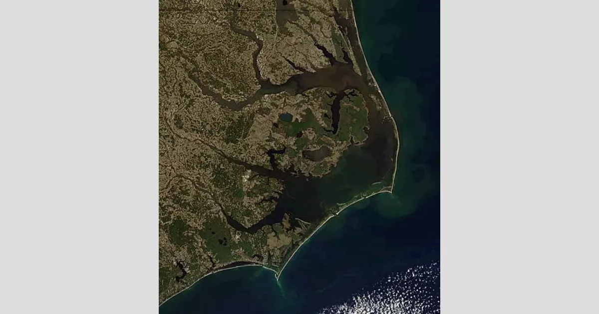
The Outer Banks are a 200-mile string of barrier islands off the coast of North Carolina and Virginia, separating several sounds from the Atlantic Ocean. A popular tourist destination, they are renowned for their extensive beaches and the Cape Hatteras National Seashore. The area's ecosystem is vital for biodiversity, featuring beach grasses and shrubland that help preserve the land's structure.
December 1903: Wright Brothers' First Flight
In December 1903, Orville and Wilbur Wright flew their Wright Flyer for 12 seconds on the dunes of Kitty Hawk, North Carolina, achieving the first heavier-than-air flight in recorded history.
December 17, 1903: Wright brothers' first flight
On December 17, 1903, the Wright brothers achieved the first controlled, powered, heavier-than-air vehicle flight at Kill Devil Hills.
1930: Wright Memorial Bridge built
In 1930, the Wright Memorial Bridge was built, connecting Point Harbor and Kitty Hawk, and was later rehabilitated in 1966.
1957: William B. Umstead Bridge built
In 1957, the William B. Umstead Bridge was built, connecting Manns Harbor and Manteo, and was later rehabilitated in 1966.
1966: Rehabilitation of the Wright Memorial Bridge
In 1966, the Wright Memorial Bridge, originally built in 1930, was rehabilitated.
2002: Virginia Dare Memorial Bridge completed
In 2002, the Virginia Dare Memorial Bridge was completed, connecting Manns Harbor and Roanoke Island.
September 18, 2003: Hurricane Isabel bisects Hatteras Island
On September 18, 2003, Hurricane Isabel created a 2,000-foot wide channel called Isabel Inlet through Hatteras Village, cutting Hatteras Island in half.
2011: Hurricane Irene cuts off Hatteras Island again
In 2011, Hatteras Island was cut off once again by Hurricane Irene, limiting access to boat only from August to late October.
2011: Hurricane Irene
In 2011, Hurricane Irene caused significant destruction to infrastructure and property on the Outer Banks.
2014: Erosion on Hatteras Island
As of 2014, portions of Hatteras Island were at 25% of their original width due to significant erosion.
2015: Sea Level Rise
From 2011 to 2015, sea levels rose 5 inches in some locations on the Outer Banks.
Trending
Armenia is a landlocked country situated in the Armenian highlands of West Asia within the Caucasus region It shares borders...
2 months ago Stock Market Rises on Black Friday Amid Fed Rate-Cut Speculation: Dow, S&P, Nasdaq Up
Laura Pausini is a highly successful Italian pop singer who gained international recognition after winning the Sanremo Music Festival in...

6 months ago Leonardo DiCaprio and Vittoria Ceretti Spotted on Luxurious Yacht in Spain

Shaun White is a highly accomplished American former professional snowboarder and skateboarder A five-time Olympian he secured three Olympic gold...

3 months ago Sarah Paulson and Monica Lewinsky Discuss 'American Crime Story' and Linda Tripp Portrayal.
Popular

Kid Rock born Robert James Ritchie is an American musician...

Melania Trump a Slovenian-American former model has served as First...

XXXTentacion born Jahseh Dwayne Ricardo Onfroy was a controversial yet...

Thomas Douglas Homan is an American law enforcement officer who...

Instagram is a photo and video-sharing social networking service owned...

Jupiter is the fifth and largest planet from the Sun...


