History of San Andreas Fault in Timeline

The San Andreas Fault is a major geological feature in California, stretching approximately 750 miles (1,210 km). It marks the boundary between the Pacific and North American tectonic plates, characterized as a right-lateral strike-slip transform fault. For scientific purposes, the fault is divided into three segments, each exhibiting distinct behaviors and earthquake potential. The fault's average slip rate varies between 0.79 and 1.38 inches annually, reflecting the ongoing movement of the tectonic plates. This continuous movement poses a significant earthquake risk to the region.
5 hours ago : San Andreas Fault: Earthquake Threat Worse, Dual Rupture Possible, Cascadia Trigger?
New evidence indicates the 'Big One' earthquake threat on the San Andreas Fault may be worse than expected. A dual fault rupture poses a threat to San Francisco and Seattle, and Cascadia could trigger San Andreas.
1901: Magnitude 6.0 Earthquake in Parkfield
Seismologists recorded a magnitude 6.0 earthquake in Parkfield, California in 1901.
1906: San Andreas Fault Extends Southward
Eleven years after the fault's initial discovery, in 1906, Lawson discovered that the San Andreas Fault stretched southward into southern California after reviewing the effects of the San Francisco earthquake.
1906: Fault Extension into Southern California
Following the 1906 San Francisco earthquake, Lawson concluded that the San Andreas Fault extended into Southern California.
1906: San Francisco Earthquake Origin Deciphered
In 1906, following the San Francisco earthquake, Professor Andrew Lawson mapped offsets along surface ruptures and concluded that the San Andreas Fault was the origin of the earthquake.
1906: San Francisco Earthquake Exception
In 1906, the San Francisco earthquake was an exception because the plate movement was mostly from south to north and it was not preceded by a major quake in the Cascadia zone.
1906: Earthquake Impacted Fault
The 1906 earthquake on the northern segments of the San Andreas Fault impacted the increasing risk assessment.
1908: Fault named after San Andreas Valley
According to some of Professor Lawson's reports from 1895 and 1908, he named the fault after the surrounding San Andreas Valley.
1922: Magnitude 6.0 Earthquake in Parkfield
Seismologists recorded a magnitude 6.0 earthquake in Parkfield, California in 1922.
1934: Magnitude 6.0 Earthquake in Parkfield
Seismologists recorded a magnitude 6.0 earthquake in Parkfield, California in 1934.
1953: Lateral Movement Concluded
In 1953, geologist Thomas Dibblee concluded that hundreds of miles of lateral movement could occur along the San Andreas Fault.
1966: Magnitude 6.0 Earthquake in Parkfield
Seismologists recorded a magnitude 6.0 earthquake in Parkfield, California in 1966.
1989: Loma Prieta Earthquake
In 1989, the Loma Prieta earthquake epicenter was located in the Santa Cruz Mountains on the northern segment of the San Andreas Fault.
1992: Landers Earthquake and Plate Boundary Shift Hypothesis
Following the Landers earthquake in 1992, a hypothesis gained interest suggesting the plate boundary may be shifting eastward away from the San Andreas towards Walker Lane.
1993: Predicted Earthquake in Parkfield
Scientists predicted in 1993 that an earthquake should occur in Parkfield due to the frequency of predictable activity.
1994: Northridge Earthquake Mention
In November 2013, the U.S. Geological Survey released UCERF3, estimating that an earthquake of magnitude 6.7 or greater (i.e. equal to or greater than the 1994 Northridge earthquake) occurs about once every 6.7 years statewide.
2004: Earthquake Occurred in Parkfield
In 2004, an earthquake eventually occurred in Parkfield.
2004: SAFOD Project Begins
In 2004, the San Andreas Fault Observatory at Depth (SAFOD) project, funded by the National Science Foundation, commenced near Parkfield, California, with the aim of drilling through the fault.
2004: Work Began on SAFOD
In 2004, work began just north of Parkfield on the San Andreas Fault Observatory at Depth (SAFOD) to drill into the San Andreas Fault and install sensors.
2006: San Andreas Fault Stress Level Study
A study published in 2006 in the journal Nature by Yuri Fialko found that the San Andreas fault has reached a sufficient stress level for an earthquake of magnitude greater than 7.0 to occur.
2007: SAFOD Project
From 2004 to 2007, The SAFOD project collected core samples and made direct geophysical and geochemical observations to better understand fault behavior at depth.
2008: USGS Study on Earthquake Consequences
A 2008 USGS study assessed the physical, social, and economic consequences of a major earthquake in Southern California.
2008: Correlation Between San Andreas and Cascadia Subduction Zone
A 2008 paper found a correlation in time between seismic events on the northern San Andreas Fault and the southern part of the Cascadia subduction zone.
November 2013: UCERF3 Forecast Released
In November 2013, the U.S. Geological Survey released UCERF3, estimating the frequency of earthquakes of magnitude 6.7 or greater.
2017: HayWired Scenario Study Released
The first volume of the HayWired Scenario study was released in 2017.
2018: HayWired Scenario Study: Engineering Implications
In 2018, the second volume, Engineering Implications, of the HayWired Scenario study was published.
2021: Fact Sheet Update
As of the 2021 Fact sheet update, there are several estimates on damages ranging from the approximate people affected at home, work, effects of lifeline infrastructures such as telecommunications, and more.
2023: Link Between Lake Cahuilla and Seismic Activity
A 2023 study found a link between the water level in Lake Cahuilla (now the Salton Sea) and seismic activity along the southern San Andreas Fault.
Mentioned in this timeline

California is a U S state on the Pacific Coast...
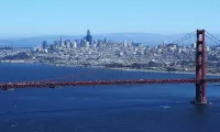
San Francisco is the fourth-most populous city in California and...
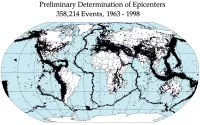
An earthquake is a sudden shaking of the Earth's surface...
Time is the continuous irreversible progression of existence from past...
The Salton Sea is a shallow saline lake in Southern...
Trending

42 minutes ago Fiji: Conservation, Luxury Resorts, and Island Life Explored by Scuba Pioneer.

42 minutes ago Naomi Osaka faces Diana Shnaider in WTA Rome; predictions and odds analyzed.

2 hours ago Ugo Humbert at ATP Rome: Predictions, Odds, and Match Updates

2 hours ago Kevin O'Leary's Utah data center faces controversy over environmental impact and political hurdles.
3 hours ago Parma's probable formation, Roma's Champions League chase, and Cuesta's pride.

4 hours ago Elina Svitolina faces Hailey Baptiste at WTA Rome for potential revenge.
Popular
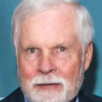
Ted Turner is an American entrepreneur and media mogul best...

Michael Joseph Jackson the King of Pop was a highly...

Rudy Giuliani is an American politician and disbarred lawyer best...
Graham Cunningham Platner is an American oyster farmer and Marine...

William Franklin Graham III known as Franklin Graham is an...

Paula White-Cain is a prominent American televangelist and key figure...