
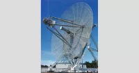
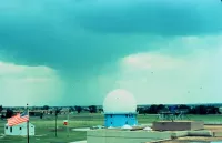
Weather radar, also known as weather surveillance radar or Doppler weather radar, is a radar technology used to detect precipitation, measure its movement, and determine its type. Modern weather radars primarily utilize pulse-Doppler technology. This allows them to identify the motion of raindrops and the intensity of precipitation. The data collected can then be analyzed to understand storm structures and predict the likelihood of severe weather events.
4 hours ago : Severe Storms Threaten Midwest With High Winds and Potential Power Outages
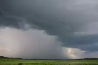
Fast-moving severe thunderstorms are impacting the Midwest, bringing threats of 75+ mph winds, hail, and potential power outages. Weather alerts and warnings are currently in effect across Michigan and Wisconsin as residents prepare for hazardous conditions.
1900: Comparison to the 1900 Galveston hurricane
The alert and evacuation made possible by the weather broadcast about hurricane Carla is compared to the 1900 Galveston hurricane which killed an estimated 6000-12000 people.
1950: Incorporation of Reflectivity Radars
Between 1950 and 1980, reflectivity radars, which measure the position and intensity of precipitation, were incorporated by weather services around the world.
1950: EKCO Demonstrates Airborne Radar
In 1950, the UK company EKCO demonstrated its airborne 'cloud and collision warning search radar equipment'.
1953: First Radar Observation of a Hook Echo
In 1953, Donald Staggs, an electrical engineer working for the Illinois State Water Survey, made the first recorded radar observation of a "hook echo" associated with a tornadic thunderstorm.
September 1961: First use of weather radar on television
In September 1961, during Hurricane Carla, Dan Rather used the U.S. Weather Bureau WSR-57 radar in Galveston to broadcast live, outlining the storm's size and location for viewers. This helped in the alerted population accepting the evacuation of an estimated 350,000 people by the authorities.
1964: NSSL began experimentation
In 1964, the NSSL began experimentation on dual polarization signals and on Doppler effect uses.
May 1973: Doppler Radar Documents Tornado Life Cycle
In May 1973, a Dopplerized 10 cm wavelength radar from NSSL documented the entire life cycle of the Union City, Oklahoma tornado, discovering a mesoscale rotation in the cloud aloft before the tornado touched the ground.
April 1974: Super Outbreak of Tornadoes
The Super Outbreak of tornadoes on 3–4 April 1974, and their devastating destruction, helped to get funding for further developments in weather radar technology.
1980: Incorporation of Reflectivity Radars
Between 1950 and 1980, reflectivity radars, which measure the position and intensity of precipitation, were incorporated by weather services around the world.
1980: Weather Radar Networks Become the Norm
Between 1980 and 2000, weather radar networks became the norm in North America, Europe, Japan, and other developed countries.
1985: Construction of the King City station
By 1985, Environment Canada constructed the King City station, with a 5 cm research Doppler radar.
1988: Construction of NEXRAD or WSR-88D
In 1988, the construction of a network consisting of 10 cm radars, called NEXRAD or WSR-88D (Weather Surveillance Radar 1988 Doppler), was started in the United States.
1993: McGill University dopplerized its radar
In 1993, McGill University dopplerized its radar (J. S. Marshall Radar Observatory).
1998: Complete Canadian Doppler network established
Between 1998 and 2004, a complete Canadian Doppler network was established.
2000: Research on Dual Polarization Technology
After 2000, research on dual polarization technology moved into operational use.
2000: Misinterpretation of Weather Radar
Around 2000, there are other objects which can be misinterpreted as rain or snow by weather radars, such as Insects and arthropods are swept along by the prevailing winds, while birds follow their own course.
2000: Weather Radar Networks Become the Norm
Between 1980 and 2000, weather radar networks became the norm in North America, Europe, Japan, and other developed countries. By the early 2000s, France and other European countries had switched to Doppler networks. Meanwhile, rapid advances in computer technology led to algorithms to detect signs of severe weather, and many applications for media outlets and researchers.
March 2003: Park Forest, Illinois, meteorite fall
An image shows the Park Forest, Illinois, meteorite fall which occurred on 26 March 2003.
2003: NSF Established CASA
Also in 2003, the National Science Foundation established the Engineering Research Center for Collaborative Adaptive Sensing of the Atmosphere (CASA).
2003: NOAA Experiments with Phased-Array Radar
Since 2003, the U.S. National Oceanic and Atmospheric Administration has been experimenting with phased-array radar as a replacement for conventional parabolic antenna to provide more time resolution in atmospheric sounding.
2004: Complete Canadian Doppler network established
Between 1998 and 2004, a complete Canadian Doppler network was established.
2005: King City Radar Dual-Polarized
In 2005, Environment Canada's radar in King City (North of Toronto) was dual-polarized; it uses a 5 cm wavelength, which experiences greater attenuation.
2008: NEXRAD Added Extra Resolution of Data
In 2008, the US NEXRAD radar network added extra resolution of data.
2009: False Positives for Tornado Vortex Signature Algorithm
In 2009, the rotating blades of windmills on modern wind farms can return the radar beam to the radar if they are in its path. In some conditions, the radar can even see toward and away velocities that generate false positives for the tornado vortex signature algorithm on weather radar; such an event occurred in Dodge City, Kansas.
April 2013: All United States National Weather Service NEXRADs were completely dual-polarized
In April 2013, all United States National Weather Service NEXRADs were completely dual-polarized.
April 2013: NEXRAD Radars Equipped with Dual-Polarization
NOAA equipped all its 10 cm NEXRAD radars with dual-polarization, which was completed in April 2013.
2014: Additional Intra-Cycle Scanning of the Lowest Level Elevation
In 2014, the US NEXRAD radar network added additional intra-cycle scanning of the lowest level elevation (MESO-SAILS).
2023: Tomorrow.io Launches Space-Based Radar
In 2023, the private American company Tomorrow.io launched a Ka-band space-based radar for weather observation and forecasting.
Mentioned in this timeline
Radar Radio Detection and Ranging is a detection system that...
Weather forecasting is the application of science and technology to...

Dan Rather is an American journalist and former national evening...
A thunderstorm also called an electrical or lightning storm is...

The National Weather Service NWS is a federal agency within...
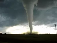
A tornado is a violently rotating column of air extending...
Trending
4 hours ago Chelsea emerge as top contender to sign midfielder Jordan Henderson

4 hours ago Pamela Anderson Stars in Twisted New Film Rosebush Pruning

4 hours ago Savannah Guthrie Shares New Video Amid Ongoing Search for Missing Mother

4 hours ago Kendra Wilkinson Faces Significant Struggles in Her Real Estate Career After Losing a Client
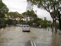
4 hours ago Severe Flash Flood Warnings Issued Amidst Heavy Downpours and Thunderstorms
4 hours ago Severe Storms Threaten Midwest With High Winds and Potential Power Outages
Popular

Nancy Grace is an American legal commentator and television journalist...

Lindsey Graham is a prominent American politician serving as the...

Johnny Depp is a highly successful American actor musician and...

LeBron James nicknamed King James is an American professional basketball...

Cristiano Ronaldo widely considered one of the greatest footballers captains...
Buc-ee's is an American chain of large country stores gas...