
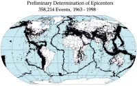
Tsunami warning systems (TWS) are designed to detect tsunamis and issue timely warnings to minimize loss of life and property damage. They consist of sensor networks for tsunami detection and a communication infrastructure for rapid alert dissemination. Two main types exist: international and regional systems. Seismic alerts initially trigger watches and warnings, which are then verified by sea level height data. Emerging research explores using T-wave energy characteristics to predict an earthquake's tsunami potential, enhancing warning accuracy.
April 1, 1946: 1946 Aleutian Islands earthquake and Tsunami
On April 1, 1946, the 1946 Aleutian Islands earthquake caused a tsunami which devastated Hilo, Hawaii. This event led to the development of more advanced tsunami warning systems.
May 23, 1960: 1960 Valdivia earthquake and Tsunami
On May 23, 1960, the 1960 Valdivia earthquake caused a tsunami which devastated Hilo, Hawaii. This event further spurred the development of more advanced tsunami warning systems.
July 12, 1993: Devastating Tsunami off the Coast of Hokkaidō, Japan
On July 12, 1993, a devastating tsunami occurred off the coast of Hokkaidō in Japan as a result of an earthquake, leading to significant loss of life on Okushiri Island.
2004: Establishment of INCOIS
In 2004, after being hit by an earthquake in Sumatra, the coasts of India were devastated by a massive tsunami, prompting the Government of India to set up the INCOIS (Indian National Centre for Ocean Information Services).
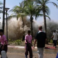
2004: 2004 Indian Ocean Tsunami
In 2004, the Indian Ocean Tsunami caused almost 250,000 fatalities.
June 2005: Establishment of the ICG/NEAMTWS
In June 2005, the Intergovernmental Oceanographic Commission of UNESCO Assembly established the Inter-governmental Coordination Group for the Tsunami Early Warning and Mitigation System in the North Eastern Atlantic, the Mediterranean and connected Seas (ICG/NEAMTWS) during its 23rd Session, through Resolution XXIII.14.
November 2005: First United Session of the ICG/NEAMTWS
On 21 and 22 November 2005, the First United Session of the Inter-governmental Coordination Group for the Tsunami Early Warning and Mitigation System in the North Eastern Atlantic, the Mediterranean and connected Seas (ICG/NEAMTWS) took place in Rome.
2005: Implementation of the Integrated Plate boundary Observatory Chile (IPOC)
In 2005, Chile began implementing the Integrated Plate boundary Observatory Chile (IPOC), a network of multiparameter stations for monitoring seismic activity.
March 2008: Planning of a Caribbean-wide tsunami warning system
In March 2008, representatives of Caribbean nations met in Panama City and planned to institute a Caribbean-wide tsunami warning system by the year 2010.
February 2010: Barbados to review tsunami protocol
In February 2010, Barbados planned to review or test its tsunami protocol as a regional pilot.
2010: IPOC recorded long-period signals after the 2010 Maule earthquake
In 2010, the long-base tiltmeters (LBTs) and the STS2 seismometer of the IPOC recorded long-period signals some days after the 2010 Maule earthquake.
2011: Tsunami warning during the 2011 Tōhoku earthquake and tsunami
During the 2011 Tōhoku earthquake and tsunami, Japan's tsunami warning system issued a warning within 3 minutes with the most serious rating on its warning scale, rated as a "major tsunami".
2012: Indonesia's Tsunami Warning System Fell Out of Service
In 2012, Indonesia's tsunami warning system fell out of service due to the detection buoys being no longer operational.
March 7, 2013: Unveiling of Improved Tsunami Warning System in Japan
On March 7, 2013, Japan unveiled an improved tsunami warning system following the 2011 disaster to better assess imminent tsunamis.
October 2013: Oceansat-2 Successfully Deployed to Predict Cyclone Phailin Landfall
In October 2013, the Oceansat-2 system was successfully deployed to predict the landfall and mitigate the effects of Cyclone Phailin.
2013: Simulations Highlighted Value of Tiltmeters and Seismometers for Tsunami Monitoring
In 2013, simulations on historical data highlighted that tiltmeters and broadband seismometers are valuable instruments for monitoring tsunamis in complement with tide gauge arrays.
December 2018: Tsunami Hit Indonesia Caused by Volcano
In December 2018, Indonesia was hit by a tsunami caused by a volcano, after which sea level sensors were installed to improve prediction.
Mentioned in this timeline

India officially the Republic of India is a South Asian...
An earthquake is a sudden shaking of the Earth's surface...

Japan is an East Asian island country located in the...
A tsunami is a series of powerful waves caused by...

Hawaii is a non-contiguous U S state located in the...

Barbados is a Caribbean island country situated in the Atlantic...
Trending

3 hours ago Julie Chen Moonves Continues Hosting Big Brother and Commenting on Reality Show Gameplay
3 hours ago San Diego Comic-Con Panelists Revealed and Negative Reviews for Will Ferrell's The Hawk

3 hours ago Juan Soto Stars With Spider-Man In New Brand New Day Commercial

3 hours ago Joe Flacco Comments Spark Media Buzz Involving Joe Burrow and Shedeur Sanders

3 hours ago Pete Buttigieg Emerges as Top Contender in Michigan 2028 Presidential Poll
3 hours ago Dalma and Gianinna Maradona Honor Their Father Diego During World Cup Events
Popular

Lindsey Graham is a prominent American politician serving as the...

Cristiano Ronaldo widely considered one of the greatest footballers captains...

Mitch McConnell is a prominent American politician and the longest-serving...

Elon Musk is a visionary entrepreneur and engineer known for...

Candace Owens is an American conservative political commentator author and...

Bernie Sanders is a prominent American politician and the senior...