History of Big Sur in Timeline

Big Sur, a mountainous region on California's Central Coast, is renowned for its breathtaking scenery where the Santa Lucia Mountains meet the Pacific Ocean. This stretch of coastline, often dubbed the "longest and most scenic" undeveloped one in the contiguous US, is celebrated for its dramatic vistas, redwood forests, hiking trails, and beaches. Attracting 4.5 to 7 million visitors annually, Big Sur is a top tourist destination, comparable in popularity to Yosemite National Park, despite having fewer amenities and infrastructure.
1900: Big Sur Population
Around 1900, Big Sur's population was recorded as only a few hundred residents less than the estimated 1,800 to 2,000 residents in recent times.
1900: Monterey County Voting Register
The 1900 Monterey County voting register recorded 61 male voters residing in Big Sur, with the majority being farmers or ranchers. Other occupations included laborer, blacksmith, and various lumber-related jobs.
1901: Fire History in Big Sur
A study of fire scars on trees revealed that at least six fires burned in the Big Sur region between 1790 and 1901. Native Americans regularly set controlled burns to manage vegetation, a practice adopted by European settlers.
1903: Chews Ridge Fire
In 1903, an unattended campfire near Chews Ridge sparked a massive fire that scorched a 6-mile wide path to the coast over three months.
1904: Birth of Esther Pfeiffer Ewoldson
Esther Pfeiffer Ewoldson, granddaughter of Big Sur pioneers Michael and Barbara Pfeiffer, was born in 1904. She later documented the informal boundaries of Big Sur, noting its gradual expansion over time.
1904: Birth of an Artistic Hub
The influx of artists from the Bay Area to Carmel-by-the-Sea in 1904 marked the beginning of Big Sur's transformation into a haven for artists and writers. This burgeoning community set the stage for Big Sur's future cultural significance.
1906: Palo Colorado Canyon Fire
A campfire's embers ignited a fire in Palo Colorado Canyon in 1906, consuming 150,000 acres over 35 days before being extinguished by the season's first rainfall.
1906: The Trotters at Palo Colorado Canyon
Sam Trotter, after purchasing Isaac Swetnam's house, moved in with his wife Adelaide Pfeiffer, daughter of Michael Pfeiffer, in 1906. They raised their family there, adding to the growing community of families establishing roots in Big Sur.
1906: Ventana Power Company Bankrupted
The 1906 San Francisco earthquake caused the Ventana Power Company, which had been logging redwoods near Pfeiffer Big Sur State Park, to go bankrupt.
1907: Notley's Landing Thrives
A small village thrived at Notley's Landing between 1898 and 1907, centered around a dog-hole port established by Notley at the mouth of the Palo Colorado River.
1907: U.S. Forest Service Takes Over Land Management
The number of fires in Big Sur decreased after the U.S. Forest Service assumed management of the land in 1907.
1909: Indigenous Presence
Forest supervisor reports from 1909 documented the continued presence of three Indigenous families residing within the Monterey National Forest, highlighting the enduring connection of native communities to the land.
1909: Gold Rush Town of Manchester Abandoned
The gold rush town of Manchester, which once had a population of 200 and various businesses, was abandoned in the early 20th century and burned to the ground in 1909.
1910: Pfeiffer's Ranch Resort Opens
John and Florence Pfeiffer opened Pfeiffer's Ranch Resort in 1910, constructing guest cabins from lumber salvaged from the defunct Ventana Power Company mill.
1911: A Glimpse of Transportation
In 1911, J. Smeaton Chase, during his travels along the California coast, observed a rudimentary transportation system in place. A stagecoach provided passage from Posts (previously known as Arbolado) to the Everett Hotel in Monterey three times a week, highlighting the challenges of accessing Big Sur at the time.
September 1914: Robinson Jeffers's Move to Carmel
Robinson Jeffers, a renowned poet, relocated to Carmel in September 1914. His arrival marked a significant moment in solidifying Big Sur's growing reputation as a hub for artists and writers.
1914: Rainfall Records Begin at Pfeiffer–Big Sur State Park
From 1914 to 1987, Pfeiffer–Big Sur State Park received an average of 43 inches (109 cm) of rainfall annually.
March 6, 1915: Big Sur Post Office Renaming
On March 6, 1915, the United States Post Office officially renamed the post office in Big Sur from Arbolado to Big Sur. The name change was initiated by local homesteaders, and the rubber stamp with the new name solidified Big Sur as the recognized place name.
1917: Preservation of Livermore Cabin
The John Little State Natural Reserve, established to protect the area around the mouth of Lime Creek, ensured the preservation of conservationist Elizabeth K. Livermore's 1917 cabin.
1920: John Junge's Cabin
Homesteader John Junge completed the construction of a modest one-room redwood cabin in 1920, adding to the developing landscape of dwellings in Big Sur.
November 18, 1921: Hearst Purchases Redwood Forest
On November 18, 1921, William Randolph Hearst, driven by a desire to preserve the untouched redwood forests, acquired approximately 1,445 acres (585 ha) of land from the Eberhard and Kron Tanning Company.
1921: Highway Construction Begins
Construction of the Carmel-San Simeon Highway, a project that would dramatically change access to Big Sur, commenced in 1921.
1923: Moving On
Sam Trotter and his family departed from their Palo Colorado Canyon home in 1923, marking the end of an era for the family at that location.
1924: Last Confirmed Grizzly Bear Sighting
The last confirmed sighting of a California grizzly bear is widely believed to have been in 1924.
1925: Hearst Acquires Rancho Milpitas
William Randolph Hearst's Piedmont Land and Cattle Company acquired Rancho Milpitas in 1925, further expanding his already vast land holdings.
1926: Funding Halt
Progress on the Carmel-San Simeon Highway was temporarily stalled in 1926 due to insufficient funding, highlighting the challenges of developing infrastructure in such a remote and geographically demanding region.
1933: Establishment of Pfeiffer Big Sur State Park
In 1933, John Pfeiffer, rejecting a developer's offer, sold 700 acres of his land to the state of California. This land became Pfeiffer Big Sur State Park, marking the start of state park preservation in Big Sur.
1937: Highway Completion
After 18 years of challenging construction, the Carmel-San Simeon Highway was finally completed in 1937. This landmark achievement paved the way for increased accessibility to Big Sur.
1937: Completion of Carmel–San Simeon Highway
In 1937, the Carmel–San Simeon Highway, now part of State Route 1, was completed after 18 years of construction. This highway, with its ocean views and winding, narrow road along seaside cliffs, greatly influenced the visitor experience of Big Sur.
1939: Highway Integration
In 1939, the Carmel-San Simeon Highway was officially integrated into the California state highway system and designated as Highway 1, marking its significance as a transportation artery.
1940: Construction of Electrified Home Near McWay Falls
In 1940, Lathrop and Hélène Hooper Brown built a grand stone cliffside house near McWay Falls, making it the region's first electrified home. The house's foundation remains a point of interest in Julia Pfeiffer Burns State Park.
1940: Rancho Milpitas Becomes Military Land
In 1940, as the United States prepared for its involvement in World War II, the U.S. War Department purchased Rancho Milpitas from William Randolph Hearst. The land was repurposed to establish a troop training facility, known as the Hunter Liggett Military Reservation.
1941: "Suspicion" Filmed in Big Sur
"Suspicion," the first movie filmed in the Big Sur region, was shot in 1941.
1941: Last Grizzly Bear Sighting (Disputed)
One account claims that the last sighting of a California grizzly bear in Monterey County was in 1941 on the Cooper Ranch, near the Little Sur River.
1944: Orson Welles and Rita Hayworth Purchase Big Sur Cabin
During a trip along the California coast in 1944, Orson Welles and his then-wife Rita Hayworth impulsively purchased a cabin in Big Sur. However, they never ended up staying there, and the property is now the site of a restaurant.
1944: Henry Miller's Arrival
In 1944, renowned author Henry Miller arrived in Big Sur at the invitation of artist Jean Varda. Initially, he found himself in a financially precarious situation, but was generously offered a rent-free stay in a cabin owned by novelist Lynda Sargent.
1944: Henry Miller Moves to Big Sur
In 1944, writer Henry Miller moved to Big Sur. His time in the region significantly influenced his writing, including his book 'Big Sur and the Oranges of Hieronymus Bosch.'
1945: Relocation and New Ownership
In 1945, the cabin Henry Miller was living in was sold to Hollywood power couple Orson Welles and Rita Hayworth. This prompted Miller's move south to a cabin on Partington Ridge, previously owned by his friend Emil White.
1946: The Anderson Creek Gang
During 1946, Henry Miller found himself living in a shack near Anderson Creek, becoming part of a bohemian collective known as the Anderson Creek Gang. This group included avant-garde musician Harry Partch and artist Jean Varda.
1947: Return to Partington Ridge
In 1947, Henry Miller returned to his familiar cabin on Partington Ridge. This return followed his time spent with the Anderson Creek Gang and marked a return to a more solitary life.
1954: Camp Pico Blanco Completed
In 1954, construction of Camp Pico Blanco, situated within a redwood forest purchased by William Randolph Hearst, was finalized by the Monterey Bay Area Council of the Boy Scouts of America.
December 1955: Record Monthly Rainfall
Big Sur experienced its wettest month in December 1955, when a record-breaking 27.21 inches (691 mm) of rain fell.
1957: Literary Exploration of Big Sur
Henry Miller published his seminal work, "Big Sur and the Oranges of Hieronymus Bosch," in 1957. This introspective blend of essay, memoir, and novel delved into the joys and challenges of embracing a life detached from the perceived artificiality of modern society.
1957: Establishment of New Camaldoli Hermitage
In 1957, the New Camaldoli Hermitage, a Catholic monastery, was founded in Big Sur. The hermitage offers silent and undirected retreats, renting out simple rooms to visitors seeking meditation and contemplation.
1960: Kerouac's Literary Inspiration
In early 1960, Jack Kerouac, drawn to the allure of Big Sur, spent time at fellow poet Lawrence Ferlinghetti's Bixby Canyon cabin. This experience would serve as the foundation for his novel "Big Sur," solidifying the region's place in literary history.
1961: Hunter S. Thompson's Time in Big Sur
In 1961, Hunter S. Thompson took on the roles of security guard and caretaker at a Big Sur Hot Springs resort, a location that would later become the Esalen Institute. During his time there, he penned his debut feature article for Rogue magazine, capturing the essence of Big Sur's artisan and bohemian culture.
1962: End of an Era
After nearly two decades of living in Big Sur, Henry Miller decided to move on in 1962. His departure marked the end of a significant chapter in Big Sur's history, as his presence had profoundly shaped the artistic landscape of the region.
1962: Captain Cooper School Land Donated
Frances Molera donated land for the Captain Cooper School in 1962, stipulating that it be named after her pioneer grandfather, Juan B. R. Cooper.
1962: Jack Kerouac Publishes "Big Sur"
Jack Kerouac, a renowned Beat Generation author, released his novel "Big Sur" in 1962, a work that prominently features the Big Sur region and went on to become one of his most famous books.
February 1963: End of Henry Miller's Residence in Big Sur
In February 1963, writer Henry Miller left Big Sur, where he had lived since 1944. Miller's time in Big Sur influenced his work, including his book 'Big Sur and the Oranges of Hieronymus Bosch.'
June 1964: First Big Sur Folk Festival
The inaugural Big Sur Folk Festival, an unintended outcome of a music seminar, took place in June 1964. Organized by Nancy Carlen, it started as a free performance for locals and evolved into an annual event.
1965: Highway 1 Designated First California Scenic Highway
In 1965, the 72-mile section of Highway 1 from Cambria to Carmel Highlands was designated as the first California Scenic Highway. This designation emphasized the scenic importance of the highway through Big Sur.
1965: "The Sandpiper" Filmed in Big Sur
The film "The Sandpiper," starring Elizabeth Taylor, Richard Burton, Eva Marie Saint, and Charles Bronson, was filmed in Big Sur in 1965.
1965: Trout Population Peak
The trout population in the south-central coast region, encompassing rivers like the Pajaro, Salinas, Carmel, Big Sur, and Little Sur, reached an estimated 4,750 fish in 1965.
1966: Scenic Road Designation Ceremony by Lady Bird Johnson
In 1966, First Lady Lady Bird Johnson led the official scenic road designation ceremony at Bixby Creek Bridge. This event marked the formal recognition of Highway 1 through Big Sur as a scenic route.
1968: Johnny Rivers Releases "Going Back to Big Sur"
Johnny Rivers wrote and recorded the song "Going Back to Big Sur," which was released on his 1968 album "Realization."
1970: Relocation of Big Sur Folk Festival
The Big Sur Folk Festival, typically held at the Esalen Institute, was moved to the Monterey County Fairgrounds in 1970.
1971: Last Big Sur Folk Festival
The Big Sur Folk Festival, held annually since 1964, came to an end after its final iteration in 1971.
1971: Founding of Big Sur River Run
The Big Sur River Run, a fundraising event for the Big Sur Volunteer Fire Brigade and the Big Sur Health Center, was established in 1971. This annual run through the redwoods has raised over $1,025,104 for the two organizations.
1972: Molera Fire Impacts Big Sur
In 1972, the Molera Fire caused significant flooding and mudslides in the Big Sur River valley during the following winter, burying parts of buildings.
1973: The Beach Boys Release "California Saga: California"
The Beach Boys released their song "California Saga: California" in 1973 on their "Holland" album, with lyrics that depict the rugged natural beauty of Big Sur and the culture of its inhabitants.
August 1, 1974: Big Sur Fire Brigade Founded
On August 1, 1974, Gary Koeppel founded the Big Sur Fire Brigade, with Walter Trotter, a prominent local figure, becoming its first fire chief.
1974: "Zandy's Bride" Set in Big Sur
The 1974 film "Zandy's Bride," featuring Gene Hackman and Liv Ullmann, was set in the Big Sur region.
1975: Dry Year at Pfeiffer–Big Sur State Park
The year 1975-1976 saw very little rainfall in Big Sur, with only 15 inches (39 cm) recorded at Pfeiffer–Big Sur State Park.
1976: California Coastal Act Establishment
The California Coastal Act was established in 1976, creating a protected coastal zone that includes the entire Big Sur coast. This act governs land use and restricts development to preserve the natural and rural character of the region.
1976: Implementation of 1976 California Coastal Act
The enactment of the 1976 California Coastal Act introduced significant challenges to infrastructure development along Highway 1 in Big Sur, making the installation of public amenities like restrooms, trash cans, and even road signs very difficult.
1976: Dry Year at Pfeiffer–Big Sur State Park
The year 1975-1976 saw very little rainfall in Big Sur, with only 15 inches (39 cm) recorded at Pfeiffer–Big Sur State Park.
1977: Big Sur Population and Housing Data
In 1977, Big Sur had 1,813 residents and 846 housing units.
1977: Marble Cone Fire
The Marble Cone Fire burned through Big Sur in 1977.
1980: Black Bears Return to Big Sur
Around 1980, American black bears began to reappear in the Big Sur area, likely expanding their territory from southern California and filling the ecological void left by the eradicated grizzly bear.
1981: Approval of Big Sur Local Coastal Plan
In 1981, the Monterey County Supervisors approved the Big Sur Local Coastal Plan. This plan emphasizes that Big Sur is meant to be an experience visitors transit through rather than a destination, severely restricting development to maintain the area's natural beauty.
1981: Opening of Henry Miller Memorial Library
The Henry Miller Memorial Library opened in 1981 as a tribute to the writer. Serving as a cultural center and tourist attraction, the library celebrates Miller's life and work and has become a gathering place for locals and literary enthusiasts.
1982: Wettest Year on Record
The highest annual rainfall recorded in Big Sur occurred during the 1982–1983 period, reaching a remarkable 88.85 inches (2,257 mm).
1983: Wettest Winter Season
The winter of 1982-1983 was the wettest on record for Big Sur. Over 178 inches (452 cm) of rain fell, although the exact total is unknown because the rain gauge failed.
1985: Rat Creek Gorda Complex Fire
The Rat Creek Gorda Complex Fire impacted Big Sur in 1985.
1986: Inception of Big Sur International Marathon
The Big Sur International Marathon, an annual event attracting around 4,500 participants, was first held in 1986. The marathon starts south of Pfeiffer Big Sur State Park and ends at the Crossroads Shopping Center in Carmel-by-the-Sea.
1986: Approval of Big Sur Local Coastal Plan
The Big Sur Local Coastal Plan was approved in 1986. It is one of the most restrictive local-use programs in the state, designed to preserve the region as open space, a small residential community, and agricultural ranching. The plan protects viewsheds and limits development density.
1987: California Condor Captive Breeding Program Begins
Faced with the brink of extinction, the last remaining wild California Condors were captured in 1987, marking the start of a captive breeding program.
1987: End of Rainfall Records at Pfeiffer–Big Sur State Park
From 1914 to 1987, Pfeiffer–Big Sur State Park received an average of 43 inches (109 cm) of rainfall annually.
1991: First Condor Release in Big Sur
After initial successes in captive breeding, the first California Condors were released back into the wild in Big Sur in 1991.
1992: Second Condor Release in Big Sur
Following the first release in 1991, more California Condors were released in Big Sur in 1992 as part of the ongoing reintroduction efforts.
1995: David Brower Publishes "Not Man Apart"
David Brower, a noted environmentalist, published his book "Not Man Apart: Photographs of the Big Sur Coast" in 1995, featuring a combination of Robinson Jeffers' poetry and photographs of the Big Sur coast.
1996: Designation as All-American Road
In 1996, Highway 1 through Big Sur was designated as one of the first All-American Roads under the National Scenic Byways Program. This federal recognition highlighted the road's national significance and scenic value.
1996: Condor Release Near Grand Canyon
In 1996, the reintroduction program for California Condors expanded beyond Big Sur, with birds being released near the Grand Canyon in Arizona.
1997: Ventana Wildlife Society Condor Releases
The Ventana Wildlife Society began releasing captive-bred California Condors in Big Sur in 1997.
2000: Big Sur Demographic and Income Data
In 2000, the median household income in the 93920 ZCTA, which includes Big Sur, was $41,304, and the median family income was $65,083. The median age was 43.2 years.
2002: Morley Baer Publishes "Stones of the Sur"
Published posthumously in 2002, "Stones of the Sur" by Carmel landscape photographer Morley Baer combined his classic black-and-white photography of Big Sur with selections of poetry by Robinson Jeffers.
2003: John Adams Composes "The Dharma at Big Sur"
John Adams composed "The Dharma at Big Sur" in 2003 for the opening of Disney Hall in Los Angeles. The piece is written for electric violin and orchestra.
2003: The Thrills Release "Big Sur"
The Irish band the Thrills released their third single, "Big Sur," in 2003 from their debut album "So Much for the City."
2005: Trout Population Decline
By 2005, the trout population in the south-central coast region had significantly declined to approximately 800 fish, a stark contrast to the 4,750 estimated in 1965.
2006: First Condor Nest in Over a Century
For the first time in over 100 years, a pair of California condors was observed nesting in Northern California, with a nest discovered in a redwood tree in 2006.
July 4, 2008: Basin Complex Fire Causes Evacuation and Economic Loss
The Basin Complex Fire in 2008 led to an eight-day evacuation of Big Sur and the closure of Highway 1, coinciding with the July 4th holiday weekend. The fire burned over 130,000 acres, destroyed 27 homes, and resulted in significant economic losses for the tourism industry.
2008: Big Sur Ranked Second in Travelers' Choice Awards
In 2008, Big Sur was ranked second among all United States destinations in TripAdvisor's Travelers' Choice Destination Awards. This recognition highlighted the scenic beauty and preserved natural environment of the region.
2008: Mapping Old Growth Redwoods
In 2008, scientist J. Michael Fay published a comprehensive map of old-growth redwoods spanning their entire range.
February 9, 2009: Record Low Temperature
The lowest temperature ever recorded in Big Sur was 26 °F (−3.3 °C) on February 9, 2009.
2010: Study on Redwood Fire Ecology
In 2010, a study was conducted that revealed fires, regardless of intensity, enhance the prevalence of redwood trees by suppressing competing species. Notably, the study found that high-severity fires were most beneficial for redwoods.
2012: Alanis Morissette Releases "Big Sur"
Alanis Morissette included a song titled "Big Sur" as an exclusive bonus track on the Target edition of her album "Havoc and Bright Lights," released in 2012. Morissette described the song as her "ode to Big Sur with all its majesty."
December 2013: Pfeiffer Fire
The Pfeiffer Fire, which burned from December 17 to 20, 2013, consumed 917 acres and destroyed 34 homes in the Pfeiffer Ridge Road and Sycamore Canyon Road vicinity.
2013: Film Adaptation of Kerouac's "Big Sur" Released
A film adaptation of Jack Kerouac's novel "Big Sur" was released in 2013, directed by Michael Polish and starring Kate Bosworth.
July 2014: Condor Population Update
As of July 2014, there were 34 free-flying California condors under the care of the Ventana Wildlife Society, contributing to a total population of 437 condors distributed across California, Baja California, and Arizona.
2014: Highway 1 Named Most Popular Drive in California
In 2014, the American Automobile Association named Highway 1 the most popular drive in California. The highway's scenic beauty and popularity among drivers were significant factors in this recognition.
2014: Alanis Morissette's "Big Sur" Released as a Single
Originally a bonus track, Alanis Morissette's song "Big Sur" was released as a single in 2014.
July 2016: Soberanes Fire Caused by Illegal Campfire
An illegal campfire in Garrapata Creek watershed started the Soberanes Fire in July 2016. The fire destroyed 57 homes before firefighters contained it. Tragically, a bulldozer operator died when his equipment overturned during firefighting efforts.
July 2016: Pine Ridge Trail Closure Due to Soberanes Fire
In July 2016, the Pine Ridge Trail, a popular hiking route into the Ventana Wilderness, was closed due to the Soberanes Fire. The fire caused significant damage to the trail and its campsites.
July 22, 2016: Soberanes Fire
On July 22, 2016, the Soberanes Fire, ignited by an illegal campfire in Garrapata State Park, ravaged 132,127 acres. This devastating fire destroyed 57 homes, 11 outbuildings, and tragically claimed the life of a bulldozer operator. It burned for nearly three months, costing an estimated $236 million to suppress.
2016: The Soberanes Fire
The 2016 Soberanes Fire caused damage to several trails and campsites within the Big Sur region.
2016: Cancellation of Big Sur River Run
The Big Sur River Run was canceled in 2016 due to the impact of the Soberanes Fire.
May 2017: Mud Creek Landslide
A massive landslide occurred at Mud Creek in May 2017, causing a significant closure of Highway 1. This event served as a stark reminder of the ongoing challenges posed by Big Sur's geological instability.
May 2017: Massive Landslide Blocks Highway
In May 2017, a 2,000,000-cubic-foot landslide blocked Highway 1 at Mud Creek, north of Salmon Creek near the San Luis Obispo County line. This event caused significant disruption until the highway was reopened in July 2018.
August 2017: Continued Closure of Pine Ridge Trail
As of August 2017, the Pine Ridge Trail remained closed due to extensive damage from the Soberanes Fire and subsequent heavy rains. Major washouts and fallen trees blocked the trail, requiring an environmental assessment for potential re-routing.
2017: 19 Movies Filmed in Big Sur
As of 2017, a total of 19 movies had been filmed in the Big Sur region, starting with "Suspicion" in 1941.
2017: Harlan Family Continues to Operate Lucia Lodge
As of 2017, the descendants of Wilber Harlan, who homesteaded near Lucia in 1885, continued to operate the Lucia Lodge.
2017: Cancellation of Big Sur River Run
Due to severe winter storms, the Big Sur River Run was canceled again in 2017.
2017: Fire and Proposed Solutions
In 2017, an illegal campfire led to a devastating wildfire in Big Sur, burning down 57 homes and tragically killing one firefighter. This event highlighted the need for better backcountry management. As a result, the Community Association of Big Sur proposed several solutions, including closing Bixby Creek parking lot, asking volunteers to prevent bridge access, requiring parking reservations for Pfeiffer Beach, prohibiting shoulder parking at McWay Falls, and banning dispersed camping during fire season.
2017: Arrest for Illegal Campfire
In October 2017, a visitor from Florida was apprehended for starting an illegal campfire that escalated into an uncontrolled blaze.
January 2018: Partial Closure of State Parks
As of January 2018, portions of most state parks in Big Sur were inaccessible due to the lasting effects of the Soberanes Fire.
January 2018: North Coast Ridge Road Closure
As of January 2018, the North Coast Ridge Road, accessible from the Ventana Inn and Limekiln State Park, was closed to vehicular traffic, bicycles, and hikers.
January 2018: State Park Trail Closures
Due to the Soberanes Fire and subsequent winter rains, many hiking trails on the east side of Highway 1 in Garrapata State Park, Andrew Molera State Park, Pfeiffer Big Sur State Park, and Julia Pfeiffer Burns State Park were closed as of January 2018. However, some trails west of Highway 1 remained open.
January 2018: Closure of Trails and Campsites
In January 2018, several trails and campsites remained closed due to the damage inflicted by the 2016 Soberanes Fire and the heavy rains that followed during the winter.
July 18, 2018: Highway 1 Reopening
On July 18, 2018, Highway 1, which had been blocked by a massive landslide in May 2017, was reopened. The slide had significantly impacted travel by blocking the highway at Mud Creek, north of Salmon Creek near the San Luis Obispo County line.
2018: Big Sur Census Data
According to the 2018 Census Bureau estimates, Big Sur had 1,728 residents and 892 housing units.
2018: Legacy of Early Settlers
As of 2018, the house built by Isaac Swetnam at the mouth of Palo Colorado Canyon, dating back to the late 19th century, still stood as a testament to the enduring legacy of Big Sur's early settlers.
June 22, 2020: Apple Announces macOS Big Sur
Apple announced their desktop operating system, macOS Big Sur, named after the Big Sur region, on June 22, 2020, during their annual Worldwide Developers Conference (WWDC).
August 18, 2020: Dolan Fire Started by Arson
The Dolan Fire, started by arson on August 18, 2020, tragically killed 12 endangered California Condors within the Big Sur Condor Sanctuary. The fire burned 125,000 acres and took over four months to contain fully.
September 7, 2020: Record High Temperature
The highest temperature ever recorded in Big Sur reached 111 °F (43.9 °C) on September 7, 2020.
September 8, 2020: Dolan Fire Destroys USFS Nacimiento Ranger Station
On September 8, 2020, the Nacimiento Ranger Station, belonging to the United States Forest Service, was destroyed by the Dolan Fire, which was started intentionally.
2020: Dolan Fire Damages Nacimiento-Fergusson Road
In 2020, following the Dolan Fire, winter storms caused significant damage to the Nacimiento-Fergusson Road, leading to its closure.
January 2022: Funding Secured for Nacimiento-Fergusson Road and Ranger Station Rebuilding
In January 2022, U.S. Representative Jimmy Panetta secured $126 million in funding to repair the Nacimiento-Fergusson Road and rebuild the USFS Nacimiento Ranger Station, both severely damaged after the 2020 Dolan Fire.
2022: Arson Conviction in Dolan Fire
Ivan Gomez was convicted on 16 felony counts, including arson, in 2022 for starting the Dolan Fire in 2020.
2023
As of 2023, the total gold extracted from the mine in Manchester is estimated to be worth about $5.49 million.
Mentioned in this timeline

California is a U S state on the Pacific Coast...
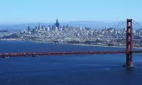
San Francisco is the fourth-most populous city in California and...

The apple is a widely cultivated edible fruit originating from...
Los Angeles is the most populous city in California and...

Arizona is a state in the Southwestern United States part...
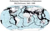
An earthquake is the shaking of the Earth's surface caused...
Trending
42 minutes ago Sal Stewart's Miami Homecoming: Strong Reds Start Against Hometown Marlins

43 minutes ago Howie Mandel's Surprise Appearance: Desmond Bane's Interview Interrupted, Creating Viral Moment
44 minutes ago Outer Banks Beach Closed Due to Collapsing Homes; Cape Hatteras Issues Warning

44 minutes ago Dominic Fike of 'Euphoria' Confirms He's a Dad, Announces Son Rocket

44 minutes ago Oliver Platt's character underutilized in Chicago Med Season 11; Dr. Charles' storyline.

45 minutes ago Sinitta reveals past relationship with Brad Pitt, Courtney Love's dating history surfaces.
Popular

Paula White-Cain is a prominent American televangelist and key figure...

William Franklin Graham III commonly known as Franklin Graham is...

XXXTentacion born Jahseh Dwayne Ricardo Onfroy was a controversial yet...

Pam Bondi is an American attorney and politician She served...

Melania Trump a Slovenian-American former model has served as First...

Steve Hilton is a British-American conservative political commentator and former...