
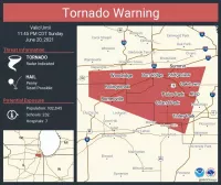
A tornado warning is issued when a tornado has been sighted or indicated by radar, signaling imminent danger. These warnings prompt people in the affected area to seek immediate shelter. Doppler radar is crucial for early detection by identifying rotation within thunderstorms before a tornado forms. Visual confirmation from weather spotters, the public, law enforcement, or emergency management personnel also triggers warnings, particularly when radar data is limited or unavailable. Ground truth observations are vital, as tornadoes can develop in radar coverage gaps.
4 hours ago : Severe Thunderstorms and Flash Flood Watches Issued Across North Jersey Region
Weather authorities have issued flash flood watches for North Jersey as severe thunderstorms move into the region. Residents are advised to prepare for heavy rainfall and potential flooding risks throughout the day.
April 1908: U.S. Weather Bureau Addresses Tornado Protection
In April 1908, the U.S. Weather Bureau published several replies regarding a question posed to the Weather Bureau on how to protect against tornadoes.
1925: High Tornado Death Rate
In 1925, the tornado death rate was 1.8 deaths per million people per year, a significantly higher rate compared to later years.
1938: Weather Bureau Rescinds Ban on "Tornado" Usage
In 1938, the Weather Bureau rescinded its ban on using the word "tornado" in weather products for emergency management personnel, marking a shift in how these events were communicated internally.
March 20, 1948: Tornado Hits Tinker Air Force Base After Erroneous Forecast
On March 20, 1948, a tornado struck Tinker Air Force Base after an erroneous forecast the previous evening, damaging several military aircraft, resulting in an estimated damage of $10 million.
March 25, 1948: First Official Tornado Forecast
On March 25, 1948, the first official tornado forecast was made by United States Air Force Capt. Robert C. Miller and Major Ernest Fawbush.
1948: Debate Restarted Over Tornado Forecast Reliability
In 1948, the relative accuracy of tornado forecasts restarted a debate over their reliability and whether military or civilian agencies should have jurisdiction over the issuance of weather warnings.
March 25, 1949: Successful Prediction of Tornado Activity in Southeastern Oklahoma
On March 25, 1949, Miller and Fawbush successfully predicted tornadic activity would occur in southeastern Oklahoma, marking another milestone in their forecasting efforts.
July 12, 1950: Ban on Tornado Warnings Lifted
On July 12, 1950, Chief of Bureau Francis W. Reichelderfer officially lifted the ban on issuing tornado warnings to the general public, advising Weather Bureau employees to not negate the bureau's ability to make tornado forecasts.
1951: Air Force Forms Severe Weather Warning Center
In 1951, the Air Force began issuing severe weather forecasts relayed to Weather Bureau offices and emergency personnel through the formation of the Severe Weather Warning Center.
March 1952: Weather Bureau Issues First Experimental Public Tornado Forecast
In March 1952, the Weather Bureau issued its first experimental public tornado forecast, which proved inaccurate but was followed by a successful forecast the following evening.
1954: First Televised Tornado Warning Broadcast
In 1954, meteorologist Harry Volkman broadcast the first televised tornado warning over WKY-TV in Oklahoma City, defying the FCC ban based on the belief that the ban cost lives.
1974: Tornado Alert Usage Declines
In 1974, the National Weather Service's use of tornado alerts began to decline. These alerts, an intermediate type of tornado advisory, indicated imminent tornado formation based on phenomena like visible cloud rotation. The tornado alert was used for many years until the early 1980s, before being phased out.
1974: Warning Times are -10 to -15 Minutes
In 1974, the average tornado warning times were substantially lower, ranging from -10 to -15 minutes, marking a significant contrast to the warning times in later years.
1974: Super Outbreak Follows Last Tornado Alert Discussion
In 1974, the last tornado alert to be officially issued was discussed in earnest following the Super Outbreak. The tornado alert was later eliminated because it was largely made obsolete by the advent of Doppler weather radar.
May 3, 1999: First Tornado Emergency Declared
On May 3, 1999, the first tornado emergency was declared when an F5 tornado struck southern portions of the Oklahoma City metropolitan area. The tornado caused major damage exceeding $1 billion. The tornado emergency is a severe weather statement with enhanced wording disseminated when reliable sources confirm a violent tornado is ongoing and poses a catastrophic risk.
2000: Decline in Tornado Death Rate
By 2000, the tornado death rate had declined to 0.11 per million people per year, largely credited to improvements in the tornado warning system.
September 20, 2002: Tornado Emergency Declared in Indianapolis
On September 20, 2002, a tornado emergency was declared within the initial issuance of the tornado warning for an F3 tornado that struck the Indianapolis, Indiana metropolitan area. This illustrates that tornado emergencies can be declared at the onset of a tornado warning under certain conditions.
October 2007: Warnings Issued Per-County Prior to October 2007
Prior to October 2007, warnings were issued by the National Weather Service on a per-county basis.
2008: Emergency Management Ontario Implements Alert System
In 2008, Emergency Management Ontario implemented a system issuing red alerts for sections of the province under an Environment Canada-issued tornado warning. This system can sometimes override the tornado warning if local government or media outlets participate in the program. The alerts are intended to inform the public about potential tornado threats.
March 2012: NWS Implements Impact Based Warning (IBW) System
In March 2012, the NWS implemented a multi-tier Impact Based Warning (IBW) system to notify the public and emergency management officials of the severity of specific severe weather phenomena.
March 2013: Expansion of Threat and Damage Indicators
In March 2013, the NWS expanded the threat and damage indicators to 33 additional Central Region WFOs.
2013: Average Tornado Warning Time Increases to 15 Minutes
As of 2013, the average tornado warning times have increased to about 15 minutes, showing improvement in technology and warning systems.
March 2014: Further Expansion of IBW Indicators
In March 2014, eight additional offices operating within the Eastern, Southern and Western Region divisions began using the IBW indicators.
2016: Nationwide Implementation of IBW Format
In 2016, the entire agency began using the Impact Based Warning (IBW) format.
August 15, 2020: First Tornado Warning Issued for Pyrocumulonimbus
On August 15, 2020, the National Weather Service issued the first tornado warning for pyrocumulonimbus capable of producing a tornado in southeastern Lassen County, California.
July 2021: IBW Fully Implemented for Individual Warning Bulletins
In July 2021, IBW formatting was fully implemented for other individual warning bulletins, and all NWS offices incorporated damage threat indicators into severe thunderstorm warnings.
April 2023: Introduction of the TORNADO Act
In April 2023, U.S. Sen. Roger Wicker introduced the Tornado Observation Research Notification and Deployment to Operations (TORNADO) Act to improve severe weather prediction and communication.
Mentioned in this timeline

California is a U S state on the Pacific Coast...
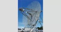
Radar Radio Detection and Ranging is a detection system that...
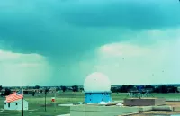
Weather radar also known as weather surveillance radar or Doppler...
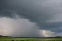
A thunderstorm also called an electrical or lightning storm is...
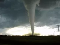
A tornado is a violently rotating column of air extending...

The National Weather Service NWS is a federal agency within...
Trending

3 hours ago Manager Predicts Usman Nurmagomedov Would Defeat UFC Champion Ilia Topuria in Potential Matchup

3 hours ago Jonah Hill Uses Jiu-Jitsu Training To Shed Superbad Fat Guy Image
4 hours ago Severe Thunderstorms and Flash Flood Watches Issued Across North Jersey Region
4 hours ago Magnitude 5.6 Earthquake Strikes Egypt and Felt Across Southern Israel
6 hours ago Alex Call and Eric Lauer Make Impact During MLB Trade Deadline Rumors

6 hours ago Emma D'Arcy's Alicent Hightower Faces Critical Moment in House of the Dragon
Popular

Rand Paul is an American politician and the junior United...

Anthony Stephen Fauci is a prominent American physician-scientist and immunologist...

Lindsey Graham is a prominent American politician serving as the...

Josh Hawley is an American politician and attorney currently serving...

Bernie Sanders is a prominent American politician and the senior...

Johnny Depp is a highly successful American actor musician and...